Where? This is the fundamental question that guides any site selection decision. Behind the economics driving a company to expand or relocate lies a geographic, or spatial, problem that must be solved. Geographic information systems (GIS) allows for the aggregation, analyzation, and visualization of spatial data and provides significant benefits throughout the site selection process. Simply stated, the use of GIS helps a company answer the “Where?” question.
SUITABILITY ANALYSIS
In the initial stages of a site selection project, the search region is determined. The overarching goal at this point in the process is to determine which areas are suitable for the planned growth. A suitability analysis can be performed at the national level, at a regional scale such as the southeast, or even at a smaller geography such as a metro area. First, a list of high-level factors critical to the project’s success is formulated, and then the search region is analyzed by scoring the geographies within the search region on those factors. Using this approach, GIS can be utilized to evaluate characteristics of the labor force, proximity to critical infrastructure (utilities, interstates, universities, etc.), presence of union activity, environmental conditions, etc. The purpose is to determine the locations that best meet the project criteria. GIS is beneficial as it both aggregates the data and provides visualization of the results, allowing a project team to draw faster and more effective conclusions when comparing geographies, accelerating the project.
For instance, as part of the project parameters that are defined, a company could require that potential sites be located within 10 miles of an interstate and within 100 miles of potential raw material supply. Weighting these criteria, along with multiple other factors critical to the project, and analyzing these through GIS can provide an aggregated data set that visually highlights the geographic areas that best meet the criteria. Geographies that fulfill the requirements would be uncovered earlier in the process and subsequently designated for further analysis, resulting in savings both in time and cost spent evaluating sites.
SUPPLY CHAIN
Geography plays a major role in the success of a company’s supply chain. The ability to move raw materials and finished goods at a competitive price and speed is paramount to the bottom line of any business, and harnessing location analytics through GIS can allow for thorough supply chain analysis and positioning.
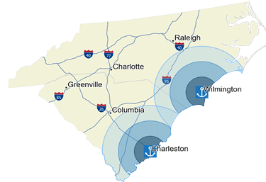 One benefit of GIS supply chain analysis is visualizing current assets – manufacturing, distribution network, inventory, etc. Understanding where the existing activity flows will be the basis for future growth decisions. Perhaps there are unrealized profits in current transportation networks (such as proximity to ports as shown in the map to the right) that can be unlocked through optimization. Fuel costs, supply of raw materials and labor are all affected by the positioning of various supply chain activities. Likewise, there may be potential suppliers closer to existing facilities that are not currently being utilized, and identifying and visualizing these through GIS could alter the direction of a project.
GIS can also aid in evaluating the geographic risk of a supply chain. Natural disasters, severe weather, proximity to competition, economic instability, or political unrest, etc. all present opportunities for interruption along the supply chain. While risks cannot be completely mitigated, careful planning and analysis of risk as it relates to existing locations and sites under consideration will help reduce interruptions, resulting in cost and time savings both immediately and long-term.
ACCESS TO TALENT
Access to and availability of skilled labor will continue to be a driving factor in site selection decisions for the foreseeable future. An in-depth workforce analysis is crucial to the success of a project and can be enhanced significantly with support from GIS capabilities. One of the more common but underappreciated uses for GIS in site selection is an analysis of drive-time areas, which calculates the area reached within a certain distance or time, and by mode of travel (car or truck). This analysis is becoming ever-more valuable with the increasingly granular level of demographic data offered at the most specific of localities.
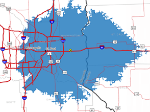 Take, for example, a site located in Washington County, Minnesota along I-94 outside of St. Paul. Without the use of GIS, one could access data on the population, labor force, wages, etc. for Washington County, and even the surrounding counties, but it would be difficult to gain a clear picture of the workforce characteristics relevant to the candidate site. Using drive-time areas, however, allows for a much more detailed demographic examination and captures the workforce that would come from St. Paul or Minneapolis, even though the site is not located in the same county. Since counties are not economic boundaries, looking at workforce from a commuter shed paints a more accurate picture of workforce characteristics for a site.
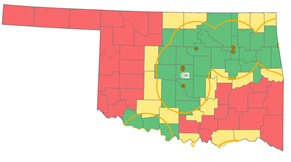 As another workforce example, locating clusters of talent in proximity to candidate sites is often a priority during the site selection process. Quest recently performed an analysis to identify the location of colleges and universities that awarded bachelor’s degrees in engineering in 2019. While a list of educational institutions can certainly be analyzed outside of GIS, the benefit of data visualization helped the team quickly evaluate where the desired talent was being produced within Oklahoma. As demonstrated in both scenarios, analyzing data only at the county-level would not fully portray labor conditions surrounding the candidate sites – and it can be mitigated with GIS analysis.
VALUE IN VISUALIZATION
GIS is one of many tools that should be utilized throughout a comprehensive site selection process. From the initial stages of defining the search region, to supplier identification and optimization of transportation networks, to detailed analysis of workforce characteristics within a commuter shed, there is great value to the type of analysis that can be performed using GIS. The static and interactive maps that can be created are effective means of visualizing and communicating spatial data, proving vital in selecting the optimal site.
Quest Site Solutions helps companies decide where to locate facilities. We assist our clients with the selection of the optimal location to meet their strategic and operational goals through detailed analysis and incentive negotiations. Quest’s consulting process enables our clients to avoid risk and make defendable, informed site selection decisions.
The research team provides data analysis in support of site selection and economic development consulting services. They assist project teams with site and infrastructure assessments, demographic analyses, labor market evaluations, financial modeling and tax and incentive review.